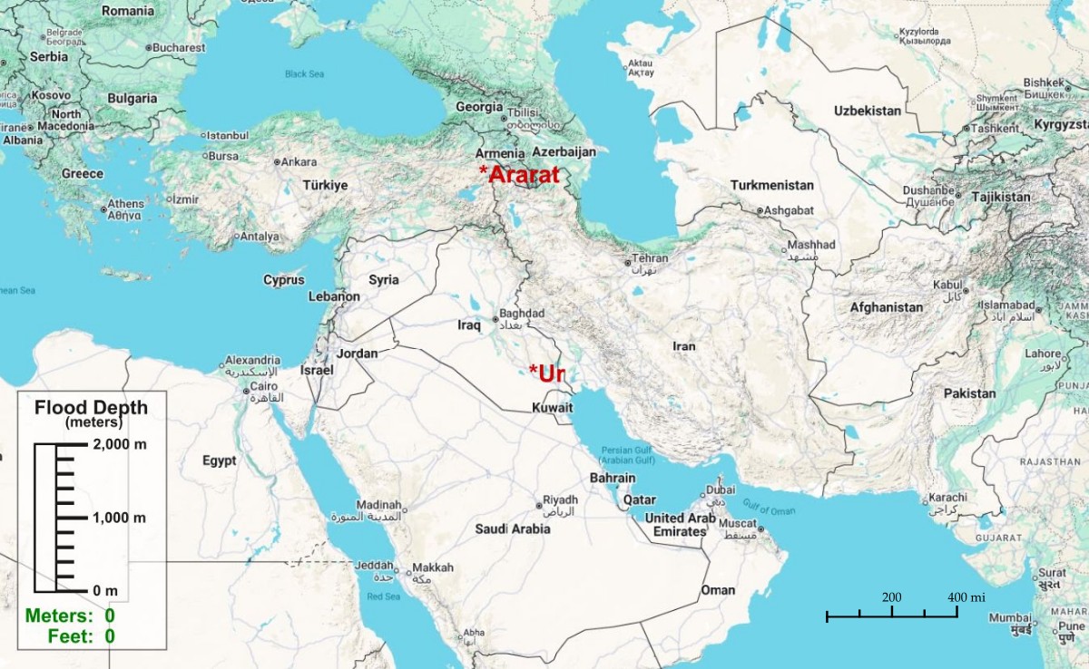
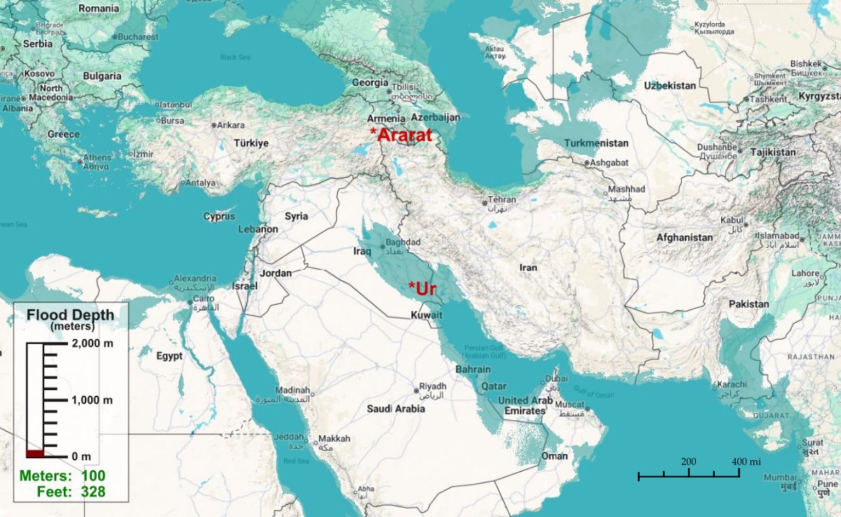
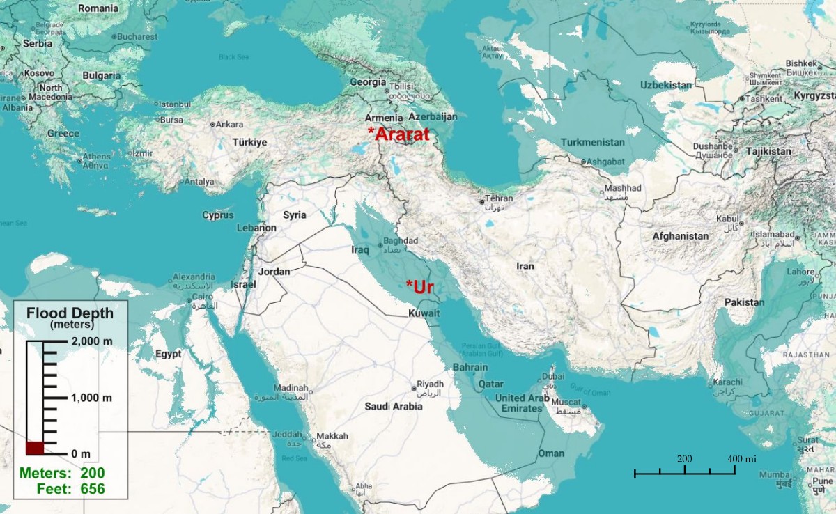
If Noah’s Flood took place in Mesopotamia, and if the terrain today is roughly the same terrain Noah had back then, here’s what the flood would have looked like if the city of Ur was underwater.
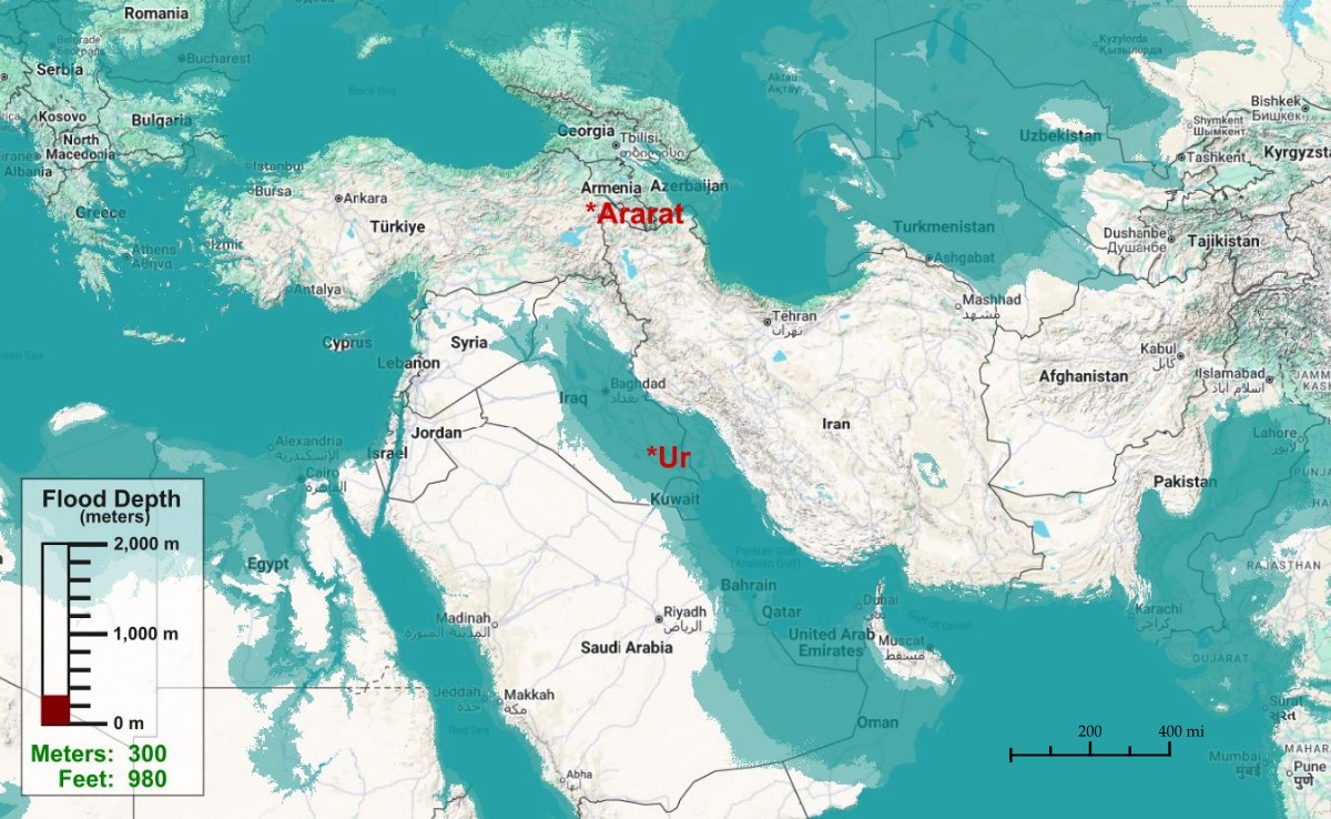
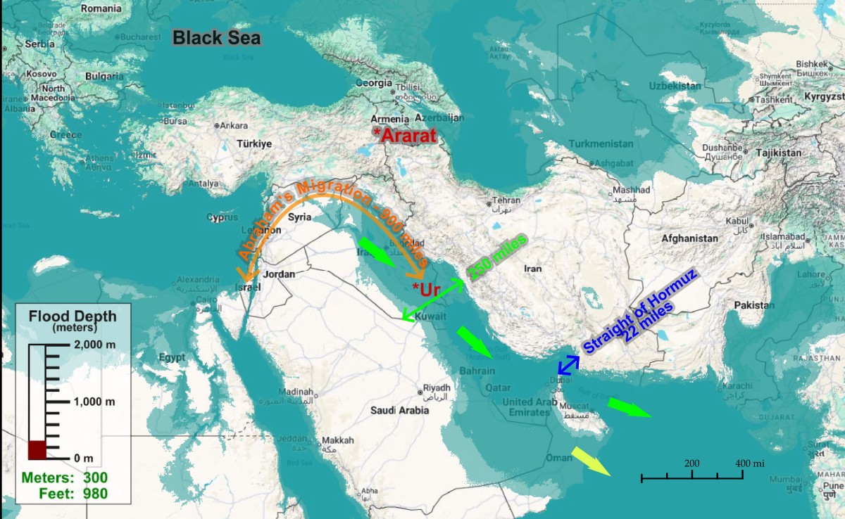
Use the left/right arrows to cycle through the images of various flood stages. The last map is a diagram with explanatory markups. Then read the comments at the bottom of this page for some interesting insights.



Some Flood Facts and Theories
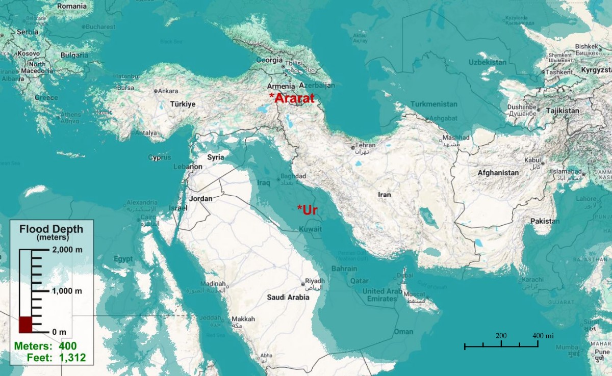
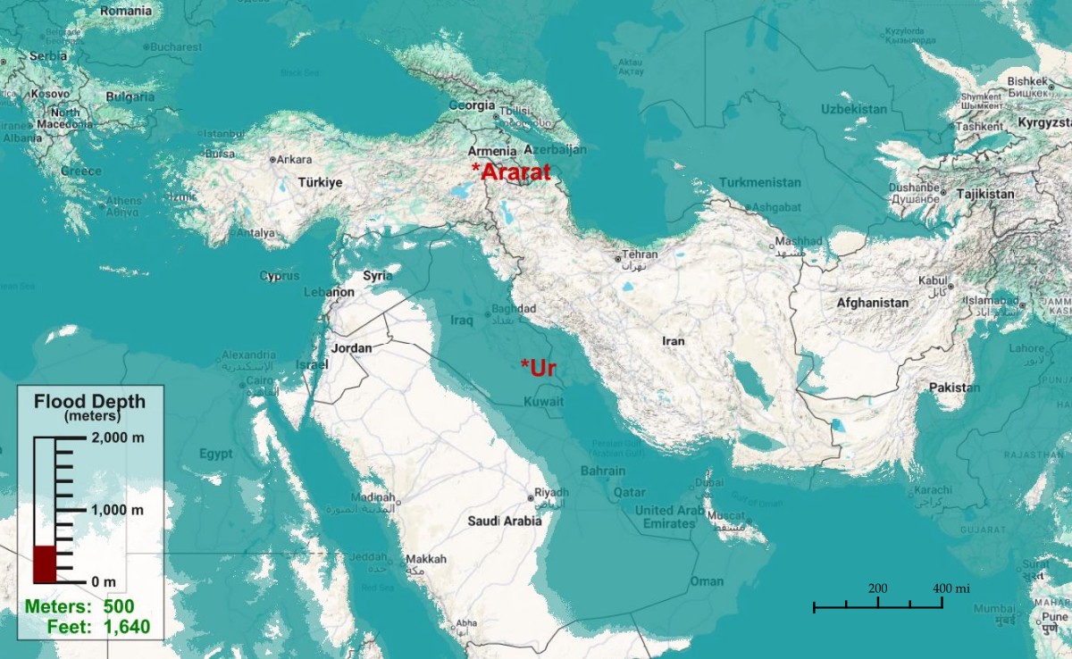
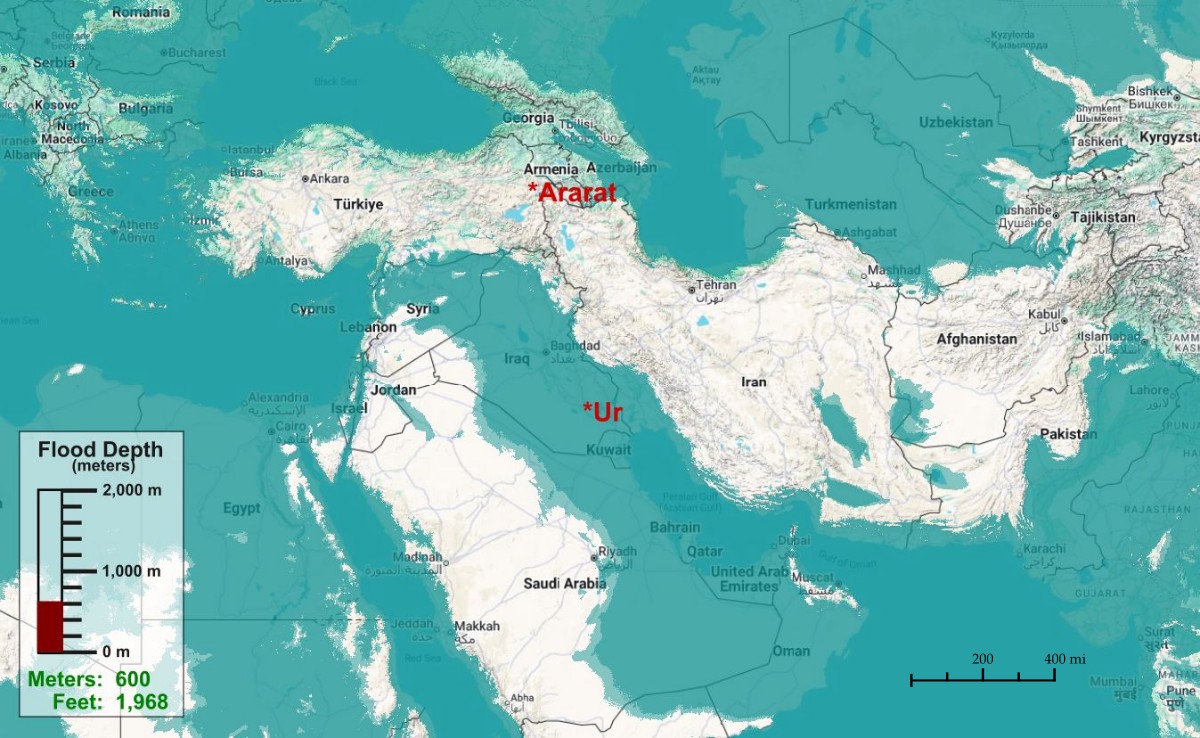
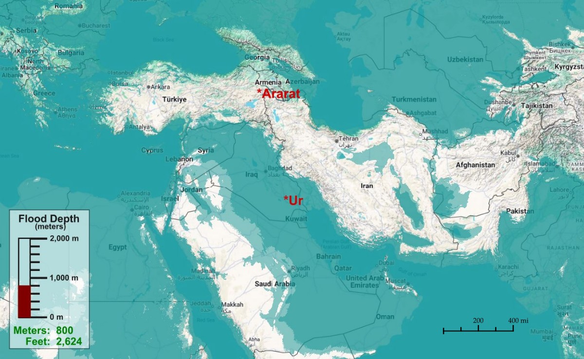
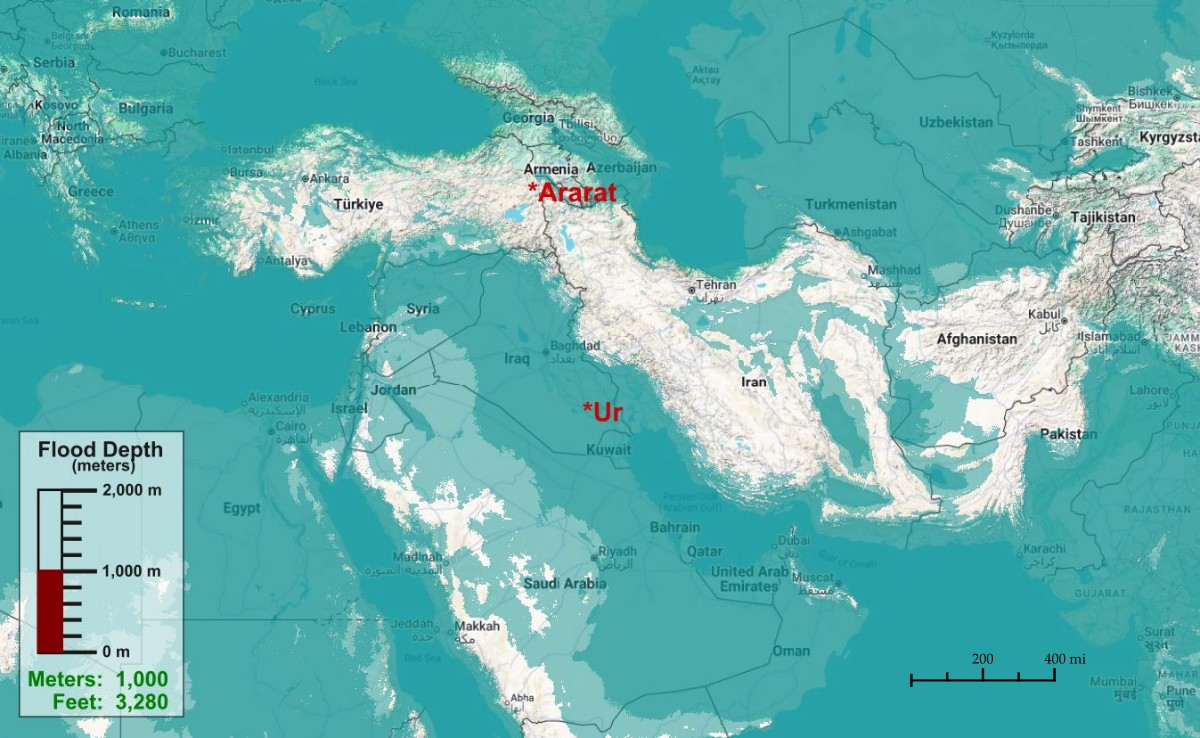
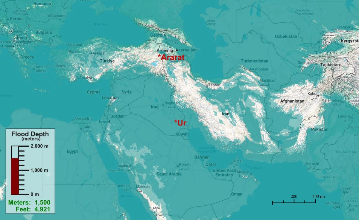
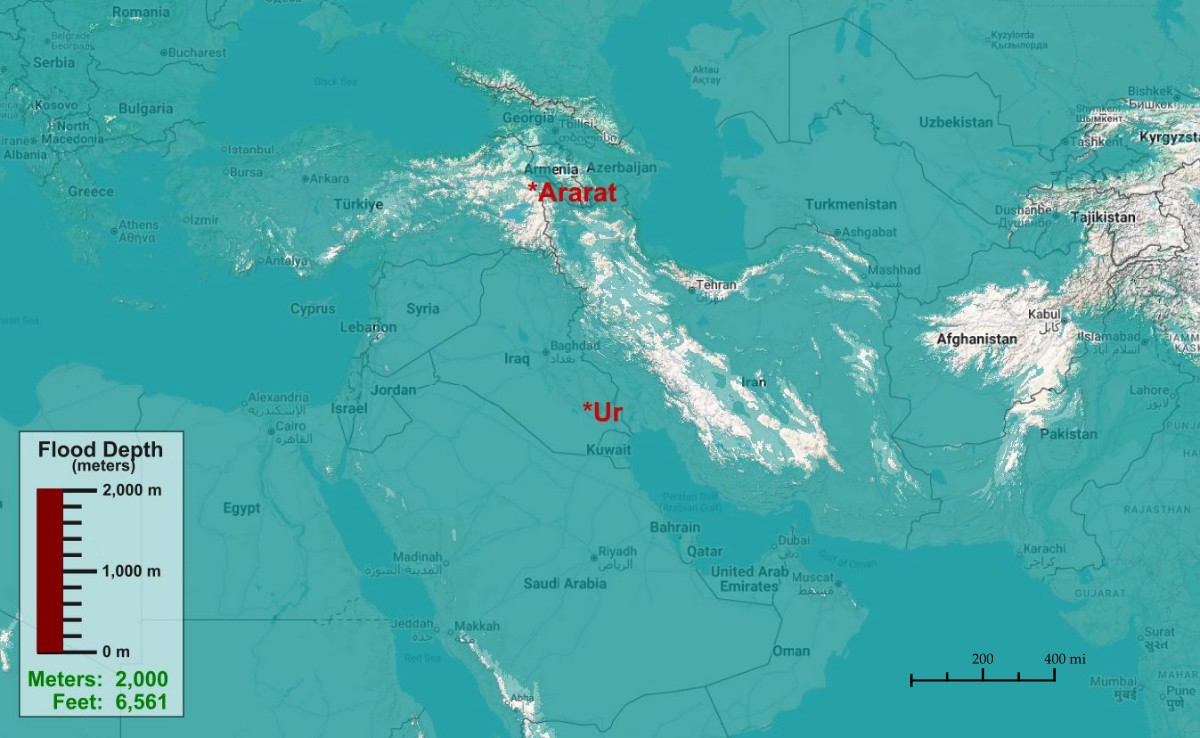
This series of maps shows what modern-day Iraq (same place as ancient Mesopotamia) would look like if Ur and Bosrah (at the coast) was flooded at various depths of water: 100m (328 ft), 200m, 300m, 400m, 500m, 600m, 800m, 1,000m, 1,500m and 2,000m (6,000ft). The last map gives us pause to examine some facts. The maps were made using QGIS and General Bathymetric Chart of the Oceans (GEBCO – 500m). If you want to make your own maps, ask ChatGPT to show you how to use QGIS. It’s kinda technical, but not that hard.
What these maps will show is that either:
- The terrain was vastly different back then than it is now (fewer mountain ranges across the planet. Maybe the ocean floor wasn’t as deep as it is today), or
- Water from rain, the Mediterranean Sea, and the Black Sea could not explain a 1-yr flood event in Mesopotamia. Thus, a major source of water for Noah’s flood would be from the ocean, through the Persian Gulf, or
- Noah didn’t originate in modern-day Mesopotamia
Proponents of a Local Flood for Noah have several theories about the source of water required to flood Mesopotamia. Some have theorized that Noah wasn’t even in Mesopotamia: he was in the Black Sea, and it suddenly overflowed with water from the Mediterranean Sea. Others have hypothesized that Noah was in Mesopotamia, and water from the Black Sea or the Mediterranean Sea flooded into Mesopotamia. Each hypothesis comes with its own set of challenges. This article will focus on flood theories where Noah is living in Mesopotamia.
The Mesopotamian Alluvial Plain
We should start with a geographical description of the terrain of Mesopotamia.
The Mesopotamian Alluvial Plain, extending from Baghdad to the Persian Gulf, is remarkably flat. Today, the region contains virtually no hills, mountains, or significant valleys. This broad plain—approximately 250 miles wide—is bounded by the Zagros Mountains to the east, the Arabian Desert to the west, the Taurus Mountains to the north, and the Persian Gulf to the south.
The land surface rises only gradually toward the north; for example, Baghdad lies roughly 115 feet above sea level despite being nearly 400 miles inland. North of Baghdad, the elevation begins to rise quickly as the terrain approaches the Taurus Mountains. Although the Mesopotamian Alluvial Plain is indeed somewhat like a large bowl, it’s shape and boundaries become quite a challenge for proponents of a local flood theory. On one hand, it doesn’t require much water to flood the shallow basin all the way from the gulf to Baghdad. But on the other hand, all that water resting on an uninhibited slope would run out to the Persian Gulf and open sea in a matter of weeks, challenging any notion of a year-long flood event.
Terrain Challenges of Various Flood Models
Here are some of the challenges of a various flood scenarios in Mesopotamia:
- For the sake of analysis, let us consider a hypothetical flood scenario in which the southern outlet (the Persian Gulf) is effectively dammed, trapping flood water within the basin of ancient Mesopotamia. Under such conditions, we would see the following:
- Rough estimates suggest that approximately 800–1,000 cubic miles (≈3,300–4,200 km³) of water would be required to submerge Basrah, the principal coastal city, beneath roughly 300 meters (≈980 feet) of water. Even at this depth, the inundation would extend only modestly north of Baghdad, indicating that such a flood—though locally deep—would remain geographically limited. Evacuating animals and people from such floodwaters would not require extensive travel.
- If the hypothetical southern barrier were suddenly removed, the stored water would rapidly discharge into the Persian Gulf. (See the green arrows on the last map.) The first significant constriction encountered would be the Strait of Hormuz, a narrow passage approximately 22 miles wide. (Blue arrow on map) While this strait would temporarily restrict outflow, it would not prevent it. Under such flood conditions, we could use Torricelli’s Law to calculate the rate at which that specified mass of water drains out to sea: approximately 2.5 months, with a nontrivial fraction (perhaps on the order of 10%) lost to evaporation in the hot, arid climate of Iraq.
- Since there is no reasonable hypothesis under which the Strait of Hormuz would be dammed up and trapping flood water in the Mesopotamian Alluvial Basin, all calculations for water entering the basin would need to also take into consideration that the water would leave the basin more-or-less as quickly as it is entering the basin. (Hugh Ross at one time hypothesized that the world was coming off an ice age, and that large mountains of ice effectively blocked the Persian Gulf and kept water from draining out of Mesopotamia for a year. It’s unclear how ice would have surrounded the Mesopotamian region without freezing out the occupants living in the region.)
- This rapid drainage presents a challenge for Biblical interpretations that require floodwaters to persist for over 1 year: Even if the total volume of water were substantially increased—for example, by doubling the flood depth to +500 meters—the system’s hydraulic response would accelerate outflow rather than prolong inundation. At greater depths, water would overtop additional coastal regions (e.g., along modern-day Oman and the Arabian Peninsula), effectively widening the outlet beyond the Strait of Hormuz by over 100 miles, and significantly increasing discharge rates. In such a scenario, all floodwaters above approximately 300 meters would drain out to open sea relatively quickly, after which the system would revert to being constrained primarily by the strait, and drainage would be completed within 2.5 months. So floodwaters 500 meters (1500ft) deep still drains out to sea on the order of months rather than a year.
- Conversely, maintaining a prolonged inundation (e.g., one year) at a depth of 300 meters would require an unrealistically narrow outlet in place of the Strait of Hormuz. Using Torricelli’s Law we could calculate the size of a 1-year drainage choke-point: the Strait of Hormuz would need to be roughly 700 feet wide instead of 22 miles wide – a tiny fraction of its current size. But the problem with a restriction of this size is that it dramatically increases water flow through the strait, which, in turn, would quickly erode such a narrow chokepoint. I think we can all rule out that scenario.
- In its current state, a 22-mile-wide strait under 300m flood conditions would result in flow speeds in excess of 40 miles per hour, significantly exceeding those observed in even the most turbulent river systems today. (EG, the Colorado River coursing through the Grand Canon reaches 12 mph). Any floating object within the Mesopotamian floodwaters would be rapidly transported toward the open sea.
- We need to consider the movements of a large raft in a flood zone, and whether it would resemble a raft on the open seas. By way of comparison, the Kon-Tiki expedition in 1948 demonstrated that a simple raft could traverse over 4,000 miles from Ecuador to the Polynesian Islands in approximately three months, driven only by ocean currents and wind. (Watch the Kon-Tiki documentary and movie.) In a large, draining inland sea, persistent currents would similarly tend to transport floating objects toward the outlet, making long-term station-keeping difficult without anchoring. Even if Noah started as far north as Baghdad, without an anchor, he would have been swept out to open sea in just a few days, long before the 40 days of rain stopped. And once he’s in open sea, there’s little point in discussing a ‘local flood’.
- For those who believe Ron Wyatt’s “ark” discovery in the mountains of Ararat really is Noah’s Ark, bear in mind that even a 2,000m (+6,000 ft) flood event doesn’t get you enough water to put the ark where Ron Wyatt claims to have discovered it. I’m not saying that it’s impossible, mind you – I’m just asking that you look at what 6,000ft of floodwaters does to the rest of the terrain in the middle east. (I have plenty of other reasons for thinking Ron Wyatt is a fraud. No offense.)
- It is worth noting that even substantial flood depths of 300m (over 1,000 ft) would not necessarily connect Mesopotamia with adjacent basins such as the Black Sea. The Taurus mountains of eastern Turkey and Zagros mountains of western Iran form a persistent topographic barrier that would prevent direct hydrological linkage under plausible flood scenarios.
- Finally, we should make note a peculiar fact about the planet: if the earth’s surface were perfectly level, the existing volume of ocean water would cover the entire planet to an average depth of roughly 1.6 miles. This highlights the immense role that topography plays – both above water and below water – in shaping how water is distributed across the globe, and, by extension, how flood events unfold.
Now let’s take time to consider other interesting elements in the flood narrative of Genesis 6-9:
- The main issue here needs to be reasserted: taking Gen 6-9 at face value, the flood lasted slightly over a year. Barring a radical transformation of the Mesopotamian topography or a supernatural event on the order of God holding back the waters of the Red Sea, there is no conceivable way that flood waters would have been contained in the Mesopotamian Alluvial Basin for a year. Regardless of the flood depths, the waters would have rushed out to open sea in just a few weeks. The plot thickens…
- Gen 7:20 – The mountain tops were covered by over 15 cubits. There are NO mountains or hills in the Mesopotamian Alluvial Basin. So what mountains is the passage referring to? This ought to suggest that Noah didn’t stay in Mesopotamia – or was quickly whisked out to open sea where no mountains were seen for a year.
- Some local-flood advocates suggest the ‘mountains’ in 7:20 simply refer to the foothills, not the tops, of the mountains being covered up to 15 cubits. Even if that were plausible, as the ark bobbed around on the water, the ark would have surely run aground if it ever touched the western side of the local flood. Recall that the western side of the Mesopotamian Alluvial Basin is a gentle slope, and even in a 1,000-ft flood, the slope would have resembled a typical shore line. Had the ark approached it, the occupants would have cried “land-ho!” and disembarked.
- The eastern side of the Basin is a cliff wall, and the ark would not have run aground on it. Instead, it might very well have been smashed to smithereens on the cliffs.)
- Gen 7:21-23 – Not only did all animals on land die, but all birds died too. If the flood was in Mesopotamia, why didn’t they simply fly the short distance to get out of the way of the flood?
- Gen 8:8-12 – A homing pigeon can fly ~600 miles per day without stopping for rest. One assumes a dove can fly about the same distance. As the waters were receding, a dove would need to fly no further than 100 miles east or west to find land. The dove’s return suggests there was no land for over 100 miles.
- Gen 12, Gen 14, etc – An additional consideration concerns terrestrial mobility. The Mesopotamian plain slopes gently upward toward the surrounding deserts and highlands, particularly to the northwest. Overland travel across such terrain is well attested historically; for instance, long-distance journeys between Mesopotamia and Canaan (modern-day Israel) were undertaken by migrant groups as they traveled through the Fertile Crescent (Abraham, Nahor, Haran, Terah. See the orange arrows on the map). Ancient armies made the same trek (4 kings of the east in Gen 14; See also 2 Kings 20:14-20; Nebuchadnezzar in 605 BC), etc. These routes demonstrate that gradual elevation gain provides accessible pathways out of the Mesopotamian lowlands. So why didn’t Noah simply herd the animals out of Mesopotamia? The trek to the highlands of ancient Haran (border of Syria/Turkey) would have been completed in a couple of months – less time than it takes to build an ark.
In consideration of the above points, I am led to the following conclusions:
- The present-day topography of Mesopotamia can not sustain a year-long regional flood of any depth.
- Noah’s flood was not in (or confined to) the Mesopotamian Alluvial Plain, or
- A series of unspecified supernatural events kept Noah’s ark in the Mesopotamian Alluvial Plain and prohibited birds from flying normally.
- The topography of the region (or likely the whole planet) changed radically during the flood or since then. [We should note that there are marine fossils on every mountain range on the planet, which means they were under water at some time in their history.]
- The Bible exaggerated many of the superfluous details of the flood including the length of time of the flood. (But flood stories can be found around the world, and if the length of time was shorter, we’re still left to wonder why Noah didn’t simply herd the animals NW and out of danger). Since I affirm that the Bible is Inspired, Inerrant, and Infallible, I don’t consider this last point to be plausible.
Regardless of which of these final points are true, personally – for a number of reasons – I believe the topography of the land in Adam-Noah’s day is quite different than it is today.
Food for thought.